Pages

Friday, November 11, 2016

Southern Utah--the second national park Capitol Reef

On Friday afternoon, October 14, after my last visit into Arches National Park, I headed off to Torrey, Utah, to visit Capitol Reef National Park.

Just as in a part of my drive from Salt Lake City, I viewed some of what I refer to as dirt mountains along the way--especially from the interstate. Except for the last two, the pictures below are not ones that I took and are actually more scenic than the dirt moutains I saw which were rising up from flatter dirt ground. There was no vegetation--nothing to divert the eye to something more attractive. The dirt mountians were broken only by gullies of water erosion running down their sides. Very rugged terrain. Very much desert terrain.


So just as in my traveling into Moab a few days ago, from this rather ugly landscape rose such beauty--beauty that we have protected by designating it a national park. I arrive at Capitol Reef National Park. The very road that I'm traveling on goes through some of the park! One of the massive domes in the park is white and reminded the earlier travelers of the US Capitol building and later inspired the name of the park.


As far as the word reef in the parks name goes, this environment was once an ocean, which by three powerful processes--deposition, unlift, and erosion gradually disappeared. Then over time a wrinkle in the Earth's crust was created, extending nearly 100 miles from Thousand Lake Mountain to Lake Powell. The result is a classic example of a monocline, or a one-sided fold, in the otherwise horizontal rock layers.  So over millions of years, geologic forces shaped, lifted, and folded the earth, creating this rugged, remote area known as the Waterpocket Fold, or as Capitol Reef National Park!

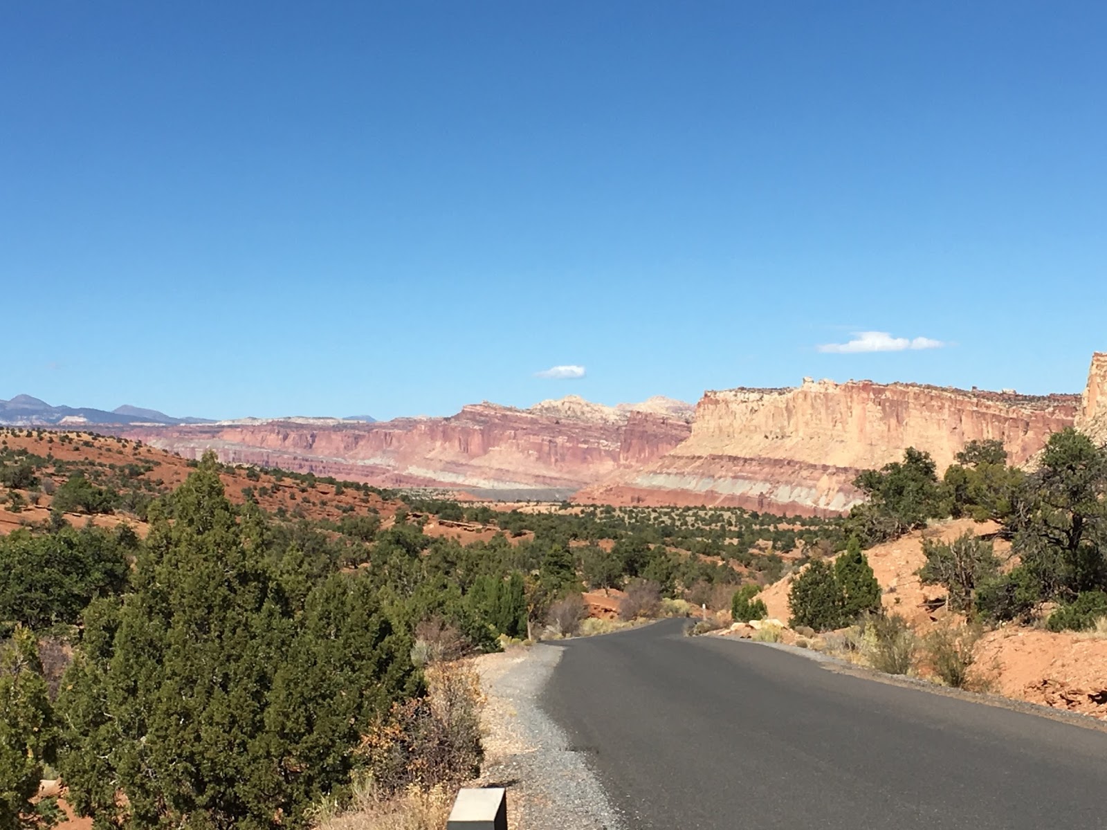
In contrast to the mono-colored desert lands that I had been traveling through, all of a sudden, a vibrant palette of color spills across the landscape. The hues are constantly changing, altered by the play of light agasinst the towering cliffs, massive domes, arches, natural bridges, and twisting canyons. Since it is October, the cottonwoods are a radiant yellow. And since the Fremont River and Sulpher Creek run through this area, the cottonwoods are lush.

In the 1880s, at the confluence of these two waterways, Mormons established a small settlement in this area that they named Fruita. They built irrigation systems to water orchards and pastures and to sustain a self-reliance agriculture lifestyle for decades. Families tended the apple, peach, pear, and apricot trees. As reminders of this pioneer time, the park still maintains these orchards, as well as the one room schoolhouse, blacksmith shop, and the Gilford homestead.

the one-room school house in the Fruita community


Carvings and paintings on rock walls are reminders of the first people who lived here from about 300-1300 CE and even earlier. These peoples are the ancestors of the modern-day Hopi, Zuni, and Paiute tribes of American Indians. They farmed the fertile land adjacent to the Fremont River and other nearby creeks and supplemented crops by hunting wildlife and harvesting nuts, berries, and seeds. No evidence of this culture is found after 1300.

Look closely and you can see the petroglyphs and pictographs on the walls made by the American Indians. 


I didn't stay in these teepees, but in a motel in Torrey--quite a nice town. It too was filled with cottonwoods. And a lovely art shop in an old house.


An ancient Carolina poplar in the backyard of the art gallery

Now here's the hardest part of Capitol Reef National Part for me to try to tell you about, and so astounded was I by this particular area that I took no pictures. Or maybe I knew the pictures wouldn't turn out. My second day in the park before I headed off to Bryce Canyon NP, I headed down a road that I had not previously been on. At first the scenery was pretty typically lots of red rock cliffs, domes, and canyons, and I almost turned around.

But then the asphalt road came to an abrupt halt, and a friend of mine from Kingston Springs who had been to Capitol Reef the year before had told me to be sure to keep going onto the dirt road. So I listened to him and kept traveling deeper into what turned out to be a gorge--a gorge that got deeper as I twisted and turned on this almost single lane dirt road. On either side of me were these towering rock walls and cliffs of various colors like nothing I had ever seen--so high and close were they that at times I could only see a ribbon of the blue sky! It was somewhat spooky and yet magnificent! It went on for several, several miles before I came to the end of the dirt road and turned around and drove slowly back to the asphalt.

That was the image that I held in my mind's eye as I made my way to the next national park that afternoon. But soon I found myself twisting and turning through a national forest, and I was at the top of this road filled on either side with already denuded white aspens.


Finally as I rose higher and higher up this mountainous road, this forest gave way to deep canyons on either side, and I was indeep on top of the world!

Except to show some of the colors and some yellow cottonwood trees all in a line further out and apparently near a river, this picture does not do justice to the deep caverns/canyons that were on either side of the road atop a narrow passageway that I was traveling.

  to be continued at Bryce Canyon National Park!

Tuesday, November 1, 2016

Southern Utah, Wow!

I had never even thought of putting the state of Utah on my bucket list until certain "signs" kept pointing me in that direction. Wow, am I now pleased that I listened to those "signs."  This is an account of my 10-day trip to Southern Utah in October, 2016--how exciting that I get to relive it as I write about it!

Flew into Salt Lake City (SLC) in Northern Utah on a Monday afternoon, October 10, drove the 4 or 5 hours to Moab in Southern Utah the next morning.

I had been to SLC before when I flew out of it after my Yellowstone and Grand Tetons trip in the spring of 2015. http://lauramallernee.blogspot.com/2015/06/a-dream-journey.html SLC is a lovely city surrounded by the Rocky Mountains, and that 75-mile-long Great Salt Lake, its 17 named islands, and its Salt Flats are definitely one of Utah's natural wonders. But I was heading out to visit some of her other natural wonders--5 national parks in Southern Utah!

On the drive to Moab, besides the landscape, which was tinged with the yellows of autumn and the bluest skies, the most interesting thing that I observed was a rancher on his horse with his Australian sherpherd in front of the horse and numerous sheep grazing on the mountainous slope behind them.


A rest stop along the way from SLC to Moab. I couldn't stop to get a picture of the sheep farmer/rancher; that picture is only in my mind's eye.

Moah is a quaint little town on the south side of Arches National Park. On Wednesday morning I made my first foray into ArchesNational Park. As soon as you pull into the park, in addition to the sculptured rock scenery--those red rocked pinnacles, balanced rocks, and towering spires--there are the dramatic La Sal Mountains in the near distance!


The park itself is filled with over 2,000 arches, ranging in size from a three-foot opening to a 306 foot opening at the base of Landscape Arch, and in contrast to all the red rock, there are the blue skies and some autumnal yellow flowers, and oh my, those luscious cottonwoods! 

I headed toward the arches named North Window and South Window and viewed them from a distance. Then took a short hike to Double Arches.


You do see the people standing there, right?!


Once you are out of your car, the park itself has an intense aura of time, silence and vast scale. Those astonishing balanced rocks are perched atop seemingly inadequate bases. Most of the animals--mule deer, kit foxes, jack-rabbits, cottontails, kangaroo rats and other rodens, and small reptile--are noctunal.


Amid the salmon-colored Entrada Sandstone rock and buff-colored Navajo Sandstone, there are explosions of color. Pinyon and juniper trees add a splash of green contrast to the red sandsone terrain. Wild flowers bloom profusely from April to July. And in this fall season, autumn flowers bloom and cottonwood trees turn the loveliest of soft yellows.    


One of my favorite sculptures was entitled "the three gossips." One of my friends quickly renamed it "the three wise women"; I like that better! 


On my second day in Moab, I took a break from driving and hiking and rafted the Colorado River, which runs south of the park on its border. There were still many red-rocked formations to view from the river, and it was one of those perfect fall days for a gentle class 3 river trip.

My third day in Moab took me back into the Arches NP that morning to see the famous Delicate Arch. Native Americans used this area for thousands of years. The Archaic peoples, and later ancestral Puebloan, Fremont, and Utes, searched the arid desert for food animals, wild food plants, and stone for tools and weapons.


If you look closely, you can see tiny specks of people hiking their way nearer to Delicate Arch. I stopped at the the trail head near Wolfe ranch, where people were beginning the three-mile hike to Delicate Arch. Most of them had come prepared for such a hike over rough terrain, with plenty of sun lotion, hats, lots of water, walking sticks, and trekking poles. I chose a shorter hike at another trail head--though I could not get as close as they, it was good enough for me!

By the way, Wolfe "ranch" was settled by two of the earlier non-native explorers. John Wesley Wolfe and his son Fred settled there in the late 1800s and operated a primitive ranch for over 20 years. Ranchers in the area found abundant grasses for cattle and sheep. All that remains of the Wolfe ranch is a weathered log cabin, root cellar, and corral. 

After I hiked to Delicate Arch, I decided to skip Canyonlands NP, which was an hour's drive in the opposite direction from where I needed to go, and drive to Capitol Reef  National Park. I'm glad I skipped CNP because I was fatigued, Even with an interstate speed limit of 80, Capitol Reef was a little further than I expected--a good 3 hours. The scenery from the interstate was not impressive, and it wasn't until I got off the interstate and onto the windy roads that I found Utah's beauty again--especially in Capitol Reef National Park. 

to be continued